The curb is the most valuable and most contested real estate in a dense urban environment. A 22-foot stretch of curb can function as a parking space, a delivery loading zone, a transit stop, a rideshare pickup point, a bike lane buffer, a food truck pad, or a pedestrian pick-up area — but only one at a time. The question of how to allocate this finite resource among competing uses, and whether that allocation should be static or dynamic, has become one of the central questions in urban transportation planning.
For most of the 20th century, the answer was almost entirely static: designate zones, paint markings, post signs, and enforce. The designation reflected planners’ estimates of typical demand, set once and reviewed infrequently. This worked tolerably well when the curb’s competing uses were limited — primarily parking and commercial loading, with buses at designated stops.
The curb is now under pressure from uses that barely existed a decade ago. Ride-hailing pickup and drop-off has created a new class of curb demand at airports, entertainment venues, and commercial districts that existing static designations cannot accommodate. E-commerce growth has increased commercial delivery demand substantially — truck deliveries to urban addresses have increased by roughly 40 percent since 2019 in major markets. Micromobility (e-scooters, e-bikes, docked bike share) requires curb space for docking stations. And parking demand itself has evolved, with the growth of short-stay parking enabled by mobile payment making curb turnover more economically valuable than all-day occupancy.
Cities are responding with a combination of policy innovation and technology: dynamic curb allocation, smart loading zones, sensor-based enforcement, and pricing that reflects real-time curb demand.
The Case for Dynamic Curb Allocation
Static curb designation fails at the margins of demand distribution. A delivery zone that is perfectly sized for 8 AM to 6 PM commercial delivery volumes is wasteful from 6 PM to midnight when delivery demand drops and passenger pickup demand peaks. A parking space designated as unrestricted overnight is appropriate for low-demand periods but underpriced during peak midday demand.
Dynamic allocation addresses this by treating the curb designation itself as a variable: the same physical space can be a parking space during low-demand hours, a delivery zone during commercial peak hours, and a rideshare pickup zone during evening entertainment peaks — with signage and enforcement adapting to the time-based designation.
This requires three enabling capabilities that static management lacks:
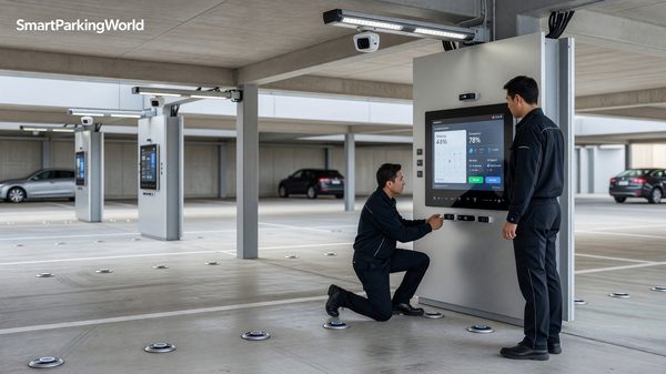
Digital signage. Fixed signs cannot communicate time-varying designations clearly enough to be enforceable. Electronic changeable message signs or smart meter displays communicate current curb status in real time.
Connected sensing. The system needs to know how the curb is actually being used — not just how it is designated. Sensors (cameras, ultrasonic, or radar) detect whether a space is occupied and what type of vehicle is present (commercial truck, passenger car, TNC vehicle with app indicator).
Enforcement integration. Dynamic allocation is only effective if violations of the current designation are enforced. Mobile LPR enforcement vehicles that know the current designation for each curb segment — updated in real time from the curb management platform — can enforce dynamic designations without relying on a fixed officer knowing the current status of every curb segment.
Smart Loading Zones: The Commercial Delivery Response
The growth of e-commerce delivery has created a genuine operational problem at the urban curb. Delivery vehicles — ranging from conventional box trucks to cargo bikes and pedestrian delivery robots — require curb access to make deliveries. When designated loading zones are unavailable (occupied by passenger vehicles, too short for the delivery vehicle, or simply absent), delivery vehicles double-park in travel lanes, occupy parking spaces that they may or may not pay for, and generally add to urban congestion and emission levels.
Smart loading zones address this through reservation systems: commercial operators (Amazon, FedEx, UPS, local delivery services) pre-book curb access for specific time windows, paying for guaranteed space availability. Sensors confirm whether the booked space is clear and occupied by the correct vehicle type. Unpaid or unauthorized occupancy triggers enforcement alerts.
The benefits are distribution of loading demand across available space and time (rather than concentration at a few default double-parking locations), revenue generation for the city from curb use that was previously unpriced, and better information for delivery operators about where they can reliably load and unload.
The Federal Highway Administration has documented smart loading zone pilots in cities including New York, San Francisco, Seattle, and Washington D.C. through its freight and curb management research programs at fhwa.dot.gov. Early data from these pilots suggests that smart loading zones can reduce commercial vehicle double-parking events by 20 to 40 percent in instrumented areas.
Dynamic Curb Pricing: What Research Shows
Dynamic curb pricing applies the same demand-responsive pricing logic that SFpark demonstrated for off-street parking to on-street and curb-level space. When demand for a curb space is high — indicated by high occupancy rates and short time-to-find-a-space measurements — prices rise. When demand is low, prices fall.
The theoretical foundation is the same as for off-street dynamic pricing: prices that achieve a target availability level (typically 1 to 2 spaces available per block face) create the maximum utilization consistent with adequate availability. At this target, drivers can reliably find a space without excessive search, and curb space is not wasted on vehicles parked below cost.
The practical implementation requires real-time occupancy sensing at the block-face level (or finer) and pricing systems that can update rates on time scales of hours to minutes. Both requirements are met by current technology.
The National Association of City Transportation Officials has published design frameworks for curb management that inform how cities structure dynamic pricing pilots, including guidance on sensor requirements and pricing update frequencies, available at nacto.org.
The Seattle Parking Benefit District Model
Seattle’s paid parking program has incorporated dynamic rate adjustments since 2011, adjusting rates quarterly based on observed occupancy data. While not fully real-time dynamic pricing, the program demonstrates that regular rate adjustments based on data improve occupancy distribution. Blocks that were chronically overpriced (low occupancy) saw rates fall; blocks that were chronically underpriced (near-zero availability) saw rates rise.
The result: more even occupancy distribution across the downtown core, reduced cruising in previously congested blocks, and modestly increased revenue from blocks brought to market rate. This data-informed rate management framework has informed subsequent dynamic curb pricing pilots in multiple U.S. and European cities.
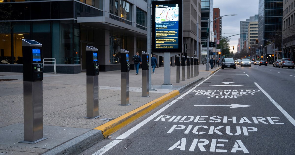
Rideshare Zone Management
TNC (Uber and Lyft) pickup and drop-off has created a specific curb management challenge: high-volume, short-duration vehicle stops at locations (airports, entertainment venues, transit stations, hotel entrances) that generate concentrated demand at predictable times. Vehicles waiting for passenger matching — or passengers waiting for vehicle arrival — create curb blockage and double-parking.
Designated TNC staging areas and dynamic pickup zones address this through three mechanisms: separating TNC pickup from parking and loading (reducing conflicts), metering TNC vehicle access to curb space (preventing excessive staging), and in some implementations, pricing TNC curb use (generating revenue from high-demand events).
Airports have been the most active site for TNC zone management, with many major airports having implemented designated rideshare pickup plazas with real-time matching that directs riders and drivers to the same location without physical searching. The Transportation Research Board has analyzed airport TNC management approaches and their traffic impacts in research accessible through trb.org.
Curb Inventory and Digital Curb Maps
A prerequisite for intelligent curb management is knowing what you have. Many cities lack complete, current, digital inventories of their curb assets: the exact location, current designation, applicable time restrictions, and condition of every curb foot.
Curb inventory creation — systematically surveying, classifying, and digitizing curb designations — is a foundational step that enables every subsequent smart management intervention. Without a digital curb map, you cannot implement dynamic designation changes, cannot integrate with navigation platforms, cannot analyze curb utilization patterns at city scale.
Cities that have invested in curb inventory have discovered that the data reveals existing problems: overlapping or contradictory designations, signs that conflict with painted markings, loading zones that are too short for the vehicles they nominally serve, and accessible spaces that don’t meet current ADA requirements.
The Access Board’s guidance on accessible curb ramps and route design is relevant to curb inventory, particularly in identifying where curb cuts and accessible routes need to be preserved and protected in dynamic allocation schemes, available at access-board.gov.
Curb inventory data is increasingly shared through open standards — the Curb Data Specification (CDS), developed by the Open Mobility Foundation — that allow navigation apps, delivery platforms, and TNC services to access current curb designation data programmatically. This integration is the infrastructure layer that makes truly intelligent curb management possible.
Technology Requirements for Dynamic Curb Management
Sensing Options for Curb Occupancy
Curb occupancy sensing faces a different geometry than off-street parking: spaces are linear rather than gridded, vehicles approach and stop at varied angles and positions, and the sensor must cover the full curb face rather than a clearly defined space boundary.
Overhead cameras mounted on streetlight poles or building facades can cover entire block faces with a single sensor, using computer vision to detect vehicle presence, vehicle type, and dwell duration. This is the most commonly deployed approach in current smart curb pilots because it provides both occupancy detection and vehicle type classification from a single sensing point.
Embedded sensors (magnetometers or ultrasonic pucks) provide binary presence detection for defined segments of curb but require separate sensors for vehicle type classification and dwell tracking. They are better suited for clearly delineated individual spaces than for flexible curb allocation.
Radar-based sensors are increasingly used for pedestrian and cyclist detection in curb zones where multiple user types need to be distinguished from vehicle occupancy.
Integration With Navigation and Delivery Platforms
The utility of dynamic curb information multiplies when it reaches the users who need it at the decision point — before they arrive at the curb. Integration with navigation platforms (Google Maps, Apple Maps, Waze) allows drivers to see current curb designation, availability, and pricing before route commitment. Integration with delivery management platforms allows dispatchers and drivers to confirm loading zone availability before committing a vehicle to a specific pickup sequence.
This integration happens through APIs that feed standardized curb data (designation, availability, pricing) to consuming platforms. The Curb Data Specification provides the semantic framework for this data exchange; city implementation determines whether the data is actually published and in what format.
The cities that are moving fastest on dynamic curb management — combining smart sensing, dynamic designation, connected enforcement, and open data publishing — are building infrastructure that will be essential as urban delivery volumes grow, autonomous vehicle operations expand, and the pressure on curb space intensifies. The static designation model that served the 20th-century curb is not adequate for the curb that 21st-century urban mobility requires.
Related reading: Curbside Management and Parking in Modern Cities for the policy context, and AI-Powered Parking Guidance Systems for the connected data infrastructure that supports curb management.
Frequently Asked Questions
What is dynamic curb allocation and how does it work?
Dynamic curb allocation changes the designated use of a curb space based on time of day or real-time demand — the same physical space might function as a parking space during off-peak hours, a delivery loading zone during commercial delivery peak hours, and a rideshare pickup zone during evening entertainment peaks. Implementation requires digital signage to communicate current designation, connected sensors to verify occupancy and vehicle type, and enforcement systems that access current designations in real time.
How do smart loading zones work for commercial delivery?
Smart loading zones allow commercial operators (Amazon, FedEx, UPS, local couriers) to reserve curb access for specific time windows through a booking system, paying for guaranteed space availability. Sensors confirm whether the booked space is clear and occupied by the correct vehicle type. Unauthorized occupancy or expired reservations trigger enforcement alerts. Early pilots in U.S. cities report 20 to 40 percent reductions in commercial vehicle double-parking events in instrumented areas.
What technology is used to sense curb occupancy?
The most common approach in current smart curb pilots is overhead cameras mounted on streetlight poles or building facades, using computer vision to detect vehicle presence, vehicle type, and dwell duration across entire block faces from a single sensor. Embedded magnetometer or ultrasonic sensors provide binary presence detection for defined segments. Radar-based sensors are used in applications requiring detection of pedestrians and cyclists as well as vehicles.
What is the Curb Data Specification (CDS)?
The Curb Data Specification is an open data standard developed by the Open Mobility Foundation that defines how curb designation, availability, and pricing data is structured and shared between cities and consuming platforms (navigation apps, delivery management systems, TNC platforms). Cities that publish curb data in CDS format allow navigation and logistics platforms to access current curb information programmatically, enabling real-time curb status information to reach drivers before they arrive.
Does dynamic curb pricing actually reduce congestion?
Research from dynamic curb pricing pilots in Seattle, San Francisco, and several European cities suggests that price-driven curb management can reduce cruise time for parking by 20 to 30 percent on instrumented block faces and improve block-face occupancy distribution. The mechanism is behavioral: higher prices during peak periods deter low-value long-duration parking and encourage shorter stays, increasing turnover and availability. The magnitude of congestion benefit depends on what share of local traffic is parking-seeking, which is highest in densely developed urban cores.
How do cities manage TNC (Uber and Lyft) curb use?
Cities manage TNC curb use through designated pickup and drop-off zones that separate TNC activity from parking and loading, real-time matching systems that direct riders and drivers to the same physical location without searching, metered TNC vehicle access to prevent excessive staging in high-demand areas, and in some cases pricing of TNC curb use at major generators like airports and stadiums. Airports have been the most active site for TNC zone management, with many major airports implementing designated rideshare plazas with connected matching systems.
Further Reading From Authoritative Sources
- FHWA — Urban Freight and Curb Management: The Federal Highway Administration documents urban freight management research including smart loading zone pilots, commercial vehicle curb access management, and data from city-scale deployments.
- NACTO — Curb Management Guidance: The National Association of City Transportation Officials publishes design guidance for curb management including dynamic allocation frameworks, sensor recommendations, and enforcement integration approaches for urban street design.