When parking operators think about occupancy sensors, the conversation usually starts with magnetometers and ends with cameras. Both are proven technologies with large installed bases and well-understood trade-offs. LiDAR — Light Detection and Ranging — occupies a different position: better known for autonomous vehicle navigation than for facility management, but increasingly deployed in structured parking for applications where conventional sensors fall short.
LiDAR emits laser pulses and measures the time of flight of the reflected signal to construct a precise three-dimensional map of the environment. In an autonomous vehicle context, this produces real-time 360-degree point clouds for navigation. In a parking facility, the same principle enables space-level occupancy detection with accuracy and capabilities that magnetometers and basic cameras cannot match.
This article examines what LiDAR sensors actually deliver in parking applications, where they outperform conventional alternatives, and what operators should know before considering a deployment.
How LiDAR Works in a Parking Context
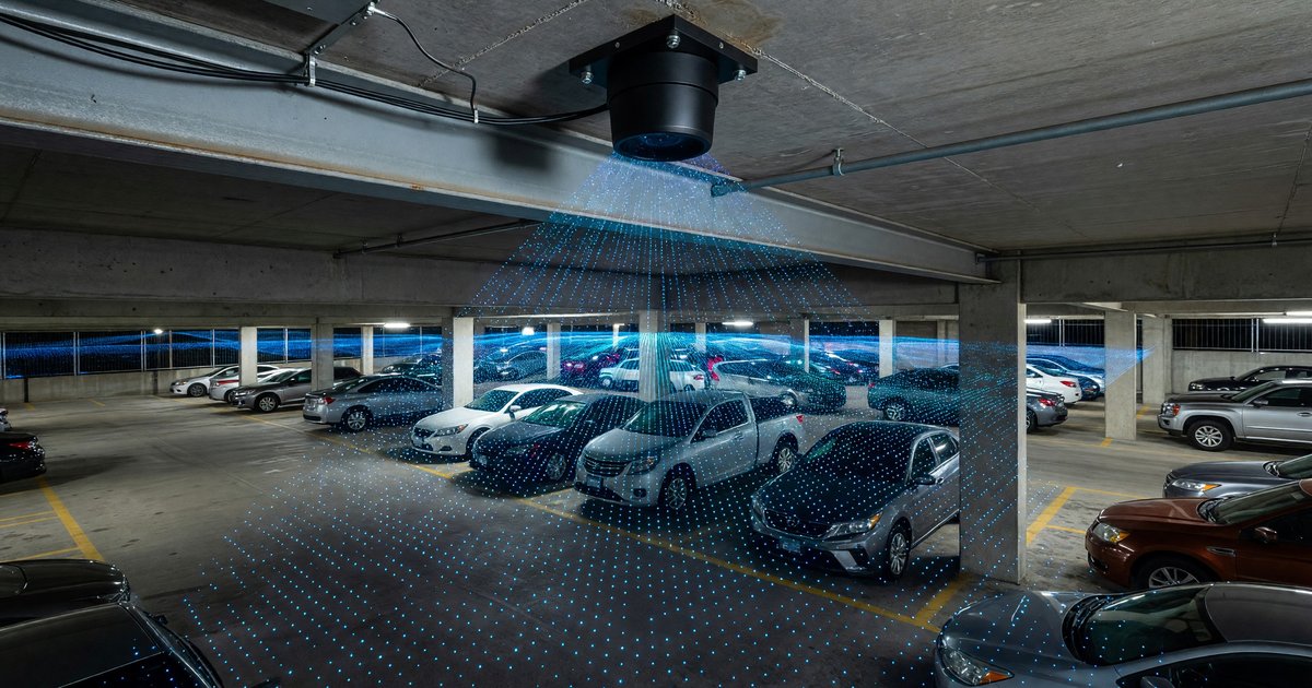
Parking-specific LiDAR sensors are typically ceiling-mounted units designed for overhead installation in covered structures. Unlike automotive LiDAR, which scans in all directions from a moving vehicle, parking LiDAR units are optimized for downward-facing detection within a defined coverage zone.
A single unit mounted at typical parking garage ceiling heights of 8 to 12 feet can monitor 4 to 8 parking spaces simultaneously, depending on the sensor’s field of view and the space geometry. The sensor generates a point cloud — a three-dimensional representation of objects within the coverage zone — and onboard or edge processing software analyzes the point cloud to determine which spaces contain vehicles.
The key technical advantage over magnetometers is dimensional richness. A magnetometer measures a single analog value (magnetic field strength) and applies a threshold to classify a space as occupied or vacant. LiDAR measures thousands of data points per second and can distinguish between a car, a motorcycle, a shopping cart, and a pedestrian with far greater reliability. The point cloud is not a binary signal; it is a spatial model.
Accuracy Advantages Over Conventional Sensors
Performance in Challenging Conditions
Magnetometer sensors are sensitive to local magnetic disturbances — nearby vehicles in adjacent spaces, underground utilities, and metallic structures can cause false reads. LiDAR is immune to magnetic interference by design. The sensor measures physical geometry, not electromagnetic fields.
Camera-based systems are sensitive to lighting conditions. Shadows, direct sun, headlights at night, and the contrast variations in parking garages affect the reliability of computer vision models. LiDAR operates using its own emitted light source and is largely insensitive to ambient lighting conditions. It functions equally well in complete darkness and full sun.
In surface lots, rain and snow affect both camera and magnetometer performance. LiDAR’s performance in precipitation varies by wavelength. Near-infrared LiDAR (905 nm, the most common in facility applications) is modestly affected by heavy rain — droplets cause return signals that can create point cloud noise. Some manufacturers mitigate this with filtering algorithms tuned to distinguish static object returns from precipitation returns. 1,550 nm wavelength LiDAR handles precipitation better but is more expensive.
Vehicle Type Classification
A key capability that distinguishes LiDAR from magnetometers and basic occupancy cameras is vehicle height detection. A LiDAR point cloud can distinguish a motorcycle from a compact car from an SUV from a commercial van — not from a badge read, but from the three-dimensional shape of the object in the space.
This matters for several operational reasons. Motorcycle-specific spaces require detecting a low-profile vehicle that magnetometers often misread as absent and cameras frequently misclassify. Height-restricted structures need to identify overheight vehicles before they cause damage. Accessibility-compliant spaces can track whether accessible vehicles (often identifiable by additional equipment height profiles) are using designated spots.
Space Geometry Accuracy
In parking structures with angled or compact spaces, adjacent vehicle geometry creates challenges for magnetometers (bleed from neighboring spaces) and cameras (line-of-sight occlusion). LiDAR’s three-dimensional data allows software to define precise detection zones within the sensor’s field of view, bounded by the physical limits of each space. A vehicle partially overlapping a space boundary is detectable in ways that a binary presence signal cannot capture.
Application Areas in Parking Facilities
Per-Space Occupancy Guidance
The most direct application is real-time occupancy data feeding a guidance system — displaying available space counts on variable message signs or mobile applications. LiDAR’s higher accuracy and vehicle-type classification capability improve guidance system reliability, particularly in structured parking where camera-based systems struggle with lighting variation and column obstructions.
For guidance accuracy, false positives (reporting a space as occupied when it is vacant) are particularly damaging — they tell drivers spaces don’t exist when they do. LiDAR’s spatial precision reduces false positives in scenarios that challenge magnetometers, specifically in compact and angled parking configurations.
Height Bar and Clearance Monitoring
Many parking structures have height clearance bars or restricted floor sections for low-clearance vehicles. Conventional monitoring relies on a physical bar that vehicles strike or on separate overhead sensors at entry points. LiDAR can monitor clearance in real time across an entire floor, providing alerts when an overheight vehicle bypasses the entry bar or when cargo shifts on a commercial vehicle.
Some facilities use LiDAR in the vehicle entry lane — not for space occupancy but for height measurement — routing overheight vehicles to appropriate sections or alerting operators before damage occurs. This is a direct cost-reduction application with a clear financial case: a single overheight vehicle collision with a ceiling structure or piping can cause damage in the tens of thousands of dollars.
People Flow Analytics
LiDAR point clouds distinguish vehicles from pedestrians. In structured parking, this dual capability enables pedestrian movement analytics alongside vehicle occupancy: detecting loitering in stairwells, monitoring pedestrian traffic in elevator lobbies, and identifying high-traffic pedestrian paths for maintenance prioritization.
This is not a standard feature in most parking-focused LiDAR implementations, but it is technically available and some operators have deployed it in facilities with safety concerns or high pedestrian volumes (airport terminals, transit-adjacent structures).
Valet and Fleet Operations
Valet operations and fleet yards benefit from LiDAR’s ability to precisely locate specific vehicles based on vehicle dimension profiles. When paired with LPR or RFID for vehicle identification at entry, a LiDAR-equipped facility can maintain a continuous spatial inventory of vehicle locations — useful for reducing retrieval time in dense valet configurations and for tracking fleet vehicle positions in large lots.
Cost Structure and Total Cost of Ownership
LiDAR sensors for parking applications cost significantly more per unit than magnetometers. Per-space hardware costs for LiDAR implementations are typically three to five times higher than magnetometer deployments on a per-space covered basis, though multi-space coverage from a single sensor partially offsets the per-space differential.
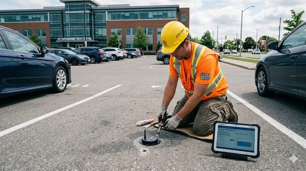
Installation in covered structures is relatively straightforward: ceiling mounting, power connection (LiDAR sensors are active devices that require continuous power, unlike battery-powered magnetometers), and network connectivity for data transmission. The requirement for power to each sensor is a meaningful infrastructure consideration — it requires conduit and electrical work rather than simply dropping a wireless battery-powered device in pavement.
Operating costs include network connectivity and software platform fees, consistent with other sensor types. Maintenance requirements are lower than magnetometers in one respect: there is no battery to replace. LiDAR sensor lifespan in facility environments is typically specified at 5 to 10 years for industrial-grade units.
Total cost of ownership favors LiDAR in applications where vehicle type classification or high-accuracy performance in difficult environments provides measurable operational value. For basic binary occupancy in a straightforward surface lot, magnetometers typically remain the lower-TCO option. For covered structures with complex requirements, the accuracy and capability premium of LiDAR becomes more justifiable.
Deployment Considerations
Ceiling Height Requirements
LiDAR sensors optimized for parking applications are designed for the ceiling height ranges typical of structured parking — roughly 8 to 14 feet. At greater heights, the point cloud density per space decreases, reducing detection accuracy. Facilities with unusually high ceilings may require sensor units designed for longer-range detection or alternative mounting configurations.
Occlusion in Dense Structures
In multi-level structures with low-profile parking, columns and beams can create blind spots in a sensor’s field of view. Pre-deployment site surveys should identify occlusion risks and plan sensor placement to ensure complete coverage. Like camera-based systems, LiDAR installations require thoughtful layout to avoid coverage gaps.
Data Processing Architecture
LiDAR sensors generate substantially more raw data than magnetometers — thousands of data points per second per sensor, versus a periodic status bit. Processing this data at the edge (within the sensor or a local gateway) rather than streaming raw point clouds to a central server is essential for bandwidth management. Most parking-focused LiDAR manufacturers include onboard processing that transmits occupancy determinations rather than raw point clouds.
The Transportation Research Board has published research on advanced sensor technologies for transportation infrastructure monitoring, including LiDAR applications in mobility contexts, available through the TRB database at trb.org.
Where LiDAR Makes Sense Today
LiDAR is not the right sensor for every parking application. For straightforward surface lot occupancy monitoring where magnetometers or cameras perform adequately, LiDAR’s higher cost is difficult to justify.
LiDAR makes the strongest case in scenarios where its specific capabilities address real operational problems: covered structures with lighting variability that undermines camera accuracy; facilities with motorcycle spaces or compact geometry where magnetometers produce excessive false reads; valet or fleet operations where vehicle classification and precise spatial location have operational value; and height-clearance monitoring applications where the cost of overheight incidents is material.
As LiDAR unit costs continue to decline — driven by automotive sector volume production — the cost differential versus conventional sensors will narrow. Deployments that are marginal today will become economically straightforward in the next three to five years. Operators planning major infrastructure investments in covered structures should include LiDAR in their sensor technology evaluation even if the initial cost comparison currently favors alternatives.
The sensor technology landscape for parking is no longer a two-horse race between magnetometers and cameras. LiDAR is a genuine third option with distinct advantages in the right applications — and understanding those advantages is essential for operators making technology decisions that will shape facility operations for the next decade.
For more on IoT sensor technologies in parking, see our overview of real-world IoT parking sensor deployments and LPWAN versus cellular connectivity options for connected parking infrastructure.
Frequently Asked Questions
What is LiDAR and how does it work in a parking garage?
LiDAR (Light Detection and Ranging) emits laser pulses and measures how long the reflected signal takes to return, building a precise three-dimensional point cloud of the environment. In a parking garage, ceiling-mounted LiDAR units use this point cloud to determine which spaces contain vehicles, typically covering 4 to 8 spaces per sensor unit with high spatial accuracy.
How accurate is LiDAR compared to magnetometer sensors?
LiDAR typically achieves 97 to 99 percent occupancy detection accuracy in covered structures versus 90 to 95 percent for magnetometers. More importantly, LiDAR is immune to the magnetic interference that causes magnetometer false reads — nearby large vehicles, underground utilities, and metallic building components all affect magnetometers but have no impact on LiDAR’s optical measurement.
Can LiDAR sensors work in outdoor surface parking lots?
Yes, though with some limitations. LiDAR handles darkness and bright sun well since it uses its own laser light source. Heavy rain and snow can introduce point cloud noise in near-infrared LiDAR units (905 nm wavelength), though most parking-focused sensors include filtering to manage this. Outdoor applications are technically feasible, but the accuracy advantage over magnetometers is less pronounced in open-air settings where magnetic interference is lower.
How much does LiDAR cost compared to conventional parking sensors?
LiDAR sensors for parking applications cost roughly three to five times more per covered space than magnetometer sensors on a hardware basis. However, one LiDAR unit covers multiple spaces, partially offsetting the per-unit cost differential. LiDAR also requires continuous electrical power, unlike battery-operated magnetometers, adding infrastructure costs. The total cost premium is typically 2 to 3 times the magnetometer TCO per space over a 10-year period.
Does LiDAR require a network connection for each sensor?
LiDAR sensors are active devices requiring continuous electrical power and a data connection to transmit occupancy determinations. Most modern parking LiDAR units process point cloud data onboard and transmit only occupancy status updates, dramatically reducing bandwidth requirements. Connectivity options include Ethernet, Wi-Fi, or cellular, depending on the manufacturer’s implementation and the facility’s network infrastructure.
What parking facilities benefit most from LiDAR sensors?
Covered structured parking with variable lighting conditions, facilities with motorcycle or compact spaces where magnetometer accuracy is poor, height-restricted structures that need continuous overheight vehicle monitoring, and valet or fleet operations that benefit from vehicle type classification. Large outdoor surface lots with standard space geometries typically see a smaller accuracy improvement over magnetometers that may not justify LiDAR’s higher cost.
Further Reading From Authoritative Sources
- Transportation Research Board — Sensors and Data for Transportation Operations: The TRB publishes research on sensor technologies across transportation infrastructure, including parking and mobility applications, through its annual program and NCHRP reports.
- ITS Joint Program Office — Emerging Sensor Technologies: The U.S. Department of Transportation’s ITS Joint Program Office tracks the deployment of intelligent transportation system technologies including advanced detection sensors for parking and traffic management.